How to Improve Margins and Customer Retention with Satellite-Based Crop Damage Assessment
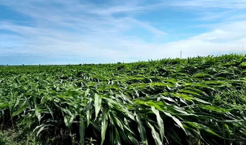
Wind damaged corn in Iowa is a common problem with significant wind storms in recent years. In this image the stalks are virtually flattened in the foreground while some corn in the background is not impacted. It is common to see this in wind damaged situations where only a portion of a field will be significantly impacted.
The 2 Minute Summary
Crop damage assessment following a severe weather or other damaging event is a major expense in crop insurance, and has a significant impact on customer satisfaction — and policy retention.
When thousands of farms are damaged at once, adjusters are stretched thin, delaying on-site crop inspections — this can increase insurer costs and frustrate farmers who need to harvest and sell or use their crops.
Unbiased remote satellite sensing can help insurers and farmers by detecting and measuring:
Flooded fields
Fire burn scars
Severe wind damage
Severe hail damage
Some crop browning
Using remote sensing can streamline damage assessment, reduce field visit claims processing costs, triage the farms that most need a site visit to assess losses not detectable by satellite, and reduce fraud and documentation errors by using historic satellite data in proving the “1 in 4” rule for claims eligibility.
This can accelerate settlement of claims and farmer payouts by as much as months or weeks.
Crop damage assessment is one of the largest operational expenses in crop insurance. It also has one of the biggest impacts on customer satisfaction. When catastrophic weather affects thousands of farms simultaneously, adjuster shortages can delay crop inspections for weeks, increasing costs for insurers while preventing farmers from harvesting, marketing, or using their crops.
Since adjuster capacity doesn't increase during catastrophic events, crop insurers need to find other ways to verify eligibility and assess damage that doesn’t involve a farm visit. Satellite imagery can provide an unbiased method for remotely measuring fields, identifying plant stress, and assessing losses.
What Crop Damage Satellites Can (and Cannot) Assess
Some types of weather and catastrophe-related crop damage can be reliably assessed from space immediately, while other types of damage take time to be detectable in satellites.
Damage That Can Be Identified Immediately
Some hazards fundamentally change the visual characteristics of a field. Because those changes have distinct spectral signatures, they can be identified almost immediately from satellite imagery.
Flooded or Waterlogged Fields: Floods are easy to distinguish with satellite imagery because water has a very different spectral signature from vegetation.
Burn Scars: Fire damage can be easily detected in satellite imagery. Wildfires are becoming an increasing source of crop damage, with farmers losing nearly 120,000 acres of dryland wheat and rangeland to fires in Oregon in 2018.
Damage that Can Often be Detected
Some hazards alter crop structure without dramatically changing the visual characteristics of the land cover. In these cases, remote crop detection depends on crop type, growth stage, and the severity of damage.
Wind Lodging:When strong winds bend or topple crop stalks, wind lodging can reduce yields by impairing plant development, increasing harvest losses, or making fields difficult to harvest. If wind blows the plants over, that structural damage can be detected with satellite imagery by comparing crop height differences from one observation to the next.
Severe Hail: Structural plant damage from severe hail can often be detected via remote sensing. However, some types of severe hail damage still leave the crop structurally intact. For example, a hailstorm could knock the pods off an entire field of soybeans while the crops remain standing. That kind of damage would be undetectable from space.
Damage that Requires Time or Additional Context
In cases where browning occurs because of the damage — like frost injury, drought, and some types of hail damage — it might take a few weeks for that damage to show up in satellite imagery, especially if cloud cover blocks any of the images in the weeks following the storm.
Damage that Still Requires Manual Inspection
Some wind storms tear leaves or cause plants to drop all of their fruit, but leave the plant’s structure mostly intact. Since the crop height and biomass are largely unaffected, this damage is difficult to assess from space. Other types of crop damage that may still require manual inspection include impacts from pests and disease.
Improving Margins and Customer Retention with Satellite-based Crop Damage Assessment
In the U.S., where the federal government sets crop insurance rates, a carrier only has two levers to pull to boost their margins and grow their crop insurance market share: claims handling and agent relationships.
Remote sensing opens up many possibilities to streamline the crop loss adjustment process and improve the customer experience at the same time.
Reduce Claims Processing Costs
Satellite imagery reduces the need for field inspections to confirm crop damage. If damage can be confirmed from space, you can skip the field visit altogether, saving the cost of the transportation, labor, and lodging required to manually inspect the damage.
Prioritize Field Inspections and Accelerate Claims Processing
Satellite imagery can tell you which fields need inspection, which can help address claims bottlenecks following severe weather events. An insurance company with 1,000 claims following a hailstorm could use remote sensing data to triage those claims. They could prioritize manual adjustment visits to the areas where damage can’t be confirmed from space, getting through all of their cases faster and keeping customers happier.
“Remote sensing opens up many possibilities to streamline the crop loss adjustment process and improve the customer experience at the same time.”
Delays in claims assessment can have ripple effects on farmers and insurers:
If the farmer feeds their grain to their animals directly they would have no way to prove their losses, so they might have to wait to use the grain until the adjuster arrives.
Waiting for an adjuster could mean the farmer will miss the best window for selling their remaining grain increasing the loss.
If a crop claim goes poorly, a policyholder might cancel other policies, like home and auto, leading to the loss of multiple revenue streams for the carrier from one unhappy policyholder.
Prove Claim Eligibility
When there are eligibility requirements that need to be met, such as the 1 in 4 rule for prevented planting claims, satellite imagery can replace other forms of documentation.
Historical satellite observations can confirm whether land was planted in prior years, identify standing water during the planting window, and help determine whether the affected acreage meets prevented planting requirements.
Reduce Fraud and Documentation Errors
Remote sensing provides an independent record that helps corroborate field conditions, planting history, and reported damage. It can help standardize claims decisions and reduce fraud because it provides objective data that can’t be influenced by the claims adjuster or the policyholder.
Fraud isn’t the only cause of misaligned payouts and losses. Human error is also rife within the agricultural ecosystem: Elevators can make measurement errors when receiving grain, semi truck drivers can mix-up paperwork on the way to the elevator, and inexperienced farmers can make honest mistakes when filing a claim. Satellite imagery can provide a more objective, accurate source of crop data to corroborate all aspects of claims.
Make Better Claims Decisions with Satellite-Assisted Crop Damage Assessment
Remote sensing can’t completely replace field inspections for crop damage assessment, but it can help insurers identify which claims can be verified remotely and which still require an adjuster, helping carriers reduce unnecessary inspections, prioritize adjuster resources, and prevent fraud.
Satellite-based crop damage assessment can expedite the insurance claims adjustment process and help insurance companies provide relief to their policyholders faster — in some cases, before harvest.
Agrograph's field-level intelligence (crop type, yield history, planting date, soil moisture, tillage, irrigation, hazard forecasting) can reduce the need for physical field visits to verify crop damage claims.
By combining satellite observations with historical production data and machine-learning models, Agrograph estimates how damage is likely to affect yields while the crop is still in the field. Instead of simply identifying flooded acres or wind damage, insurers can begin estimating production losses weeks or months before harvest.
That earlier visibility creates opportunities to accelerate claims decisions, improve reserve planning, and deliver payments to policyholders sooner.
Contact us to learn how our agricultural intelligence can help you speed up crop damage assessment to reduce claims handling costs and provide better service to policyholders.