The 2-Minute Summary
Agrograph can predict crop yield at the field level using simple field boundary coordinates — but our models are also designed to take in additional ground truth data, when it’s available. Agrograph works with customers to turn their proprietary ground truth data into reliable in-season crop yield forecasts. Our team works closely with our customers to ensure the process of acquiring customer ground truth data is as seamless as possible. While customer data is in our custody, we follow industry-standard data security processes to ensure no data is used to train models for other customers without explicit written consent and to keep data safe from bad actors.
Agrograph’s machine learning models offer something that no survey-based agricultural yield database provides: current season and historical yield predictions at the field-level. To calculate these predictions, we combine our proprietary machine learning algorithms with satellite imagery, climate data, and customer-provided ground truth data.
Given a set of field boundaries, our machine learning algorithms can predict in-season yield for major row crops by also predicting planting date and crop type from the satellite imagery.
However, for clients who have access to additional ground truth data, we can improve the accuracy of those predictions starting earlier in the season by reducing the number of input variables that have to be predicted from earth observation data.
In this blog, we’ll discuss what kind of ground truth data we can work with, how it impacts prediction accuracy, and how we obtain, use, and keep customer data safe.
Understanding the Relationship Between Ground Truth Data and Yield Prediction
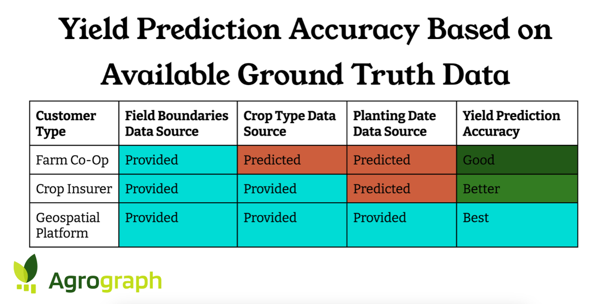
Agrograph works with a variety of customers, each bringing different levels of ground truth data. Let’s outline three different scenarios that represent typical customers to understand the relationship between available ground truth data and yield prediction accuracy.
Scenario 1: Agricultural Cooperative Provides Field Boundaries
Farm co-ops need yield predictions for their member farms to help prepare for the coming harvest. It’s common for them to have access to the field boundaries of their member farms, but to have no additional information about plant type or harvest date.
Given the GPS coordinates of the boundaries of the member fields, we can provide yield predictions that are far more reliable than statewide in-season yield predictions from NASS because they reflect the field-level topography and weather patterns.
To fill in the missing data types, we use our crop identification capabilities to predict the planting date and the crop type. We’re able to reliably identify all major row crops including, but not limited to corn, soybean, wheat, cotton, rice, sunflower, canola, and sorghum. As early as July 1, we’re able to start predicting in-season yield at the field level for corn and soybeans in the U.S.
Using predicted values for planting date and crop type, our field-level crop yield predictions are reliable enough to indicate how this year’s harvest will compare to the previous year and help co-ops plan for storage and distribution of crops at harvest.
Scenario 2: Crop Insurer Provides Field Boundaries and Crop Type
Crop insurers are often looking for field-level agricultural intelligence in regions where reliable production records are limited or nonexistent. To price risk more accurately, evaluate new markets, or design new products, they need historical and in-season yield intelligence.
Crop insurers typically have access to the field boundaries and crop types for each customer they’re trying to insure.
Using customer-provided crop types and field boundaries, combined with predicted values for planting dates, our field-level crop yield predictions are reliable enough to accurately assess risk across a crop insurer’s portfolio.
Scenario 3: AgTech Platform Provides Field Boundaries, Crop Type, and Planting Dates
When we work with geospatial platforms, they typically are able to provide a wealth of ground truth data. Their customers need accurate and timely yield predictions to react to situations as they develop during the season to maximize yield.
Using customer-provided field boundaries, crop types, and planting dates, our field-level crop yield predictions are reliable enough to inform agronomists and growers if something is wrong with a crop while there’s still time to intervene.
Agrograph’s Data Transfer, Privacy, and Security Processes
Agrograph is committed to making the process of acquiring customer ground truth data as seamless as possible and to properly stewarding that data while it’s in our custody.
Data Transfer Process
We work with each customer to accept their data in its existing format, with the goal of minimizing the effort required by their team. Typically, the only preparation step that may be required is the removal of any personally identifying information, such as people and business names.
Depending on the volume of data, it can be provided via an API or a secure cloud storage location.
Using Data to Train Models for Other Customers
Agrograph never uses customer-provided ground truth data to train models for other customers without explicit written consent. We use industry-standard tenant isolation controls and storage boundaries to ensure that one customer’s data is never accessible to another customer’s processing pipeline.
Some clients are happy to share their data to train the models for everyone. In those cases, we may offer our services at a discount.
Regardless of how it’s being used, we follow industry-standard data security processes to store all data.
Data Security Processes
We are committed to being good stewards of the data our customers entrust to us. In addition to the tenant isolation and data use limitations outlined above, our data security processes include the following protocols:
Encryption at rest: All customer data, including yield files, field boundaries, and derived analytics outputs, is encrypted at rest with AES-256 keys.
Encryption in transit: All data in transit is protected with TLS 1.2 or higher, across every ingestion endpoint, API, and internal service connection. No plaintext transfer paths exist.
Least-privilege access: Access to customer data follows least-privilege, role-based permissions with service accounts scoped to individual pipelines.
Strong authentication: All staff authenticate through single sign-on with enforced multi-factor authentication across cloud, source control, and administrative systems. Workload identity is preferred in place of long-lived credentials.
Infrastructure as code: All infrastructure is defined as code and peer-reviewed before deployment.
Audit logging and monitoring: Audit logs capture data access, and are retained for at least one year, and are monitored for anomalous activity.
Subprocessor management: Our core infrastructure runs on Google Cloud Platform, which maintains SOC 2 Type II and ISO 27001 certifications.
Agrograph Leverages Customer Ground Truth Data to Improve Yield Predictions Without Compromising Data Security or Privacy
Working with Agrograph is simple and secure, whether you have warehouses worth of ground truth data or you only know your target field boundaries. You won’t have to spend days reformatting your ground truth data in order to share it with us. Because of our strict data use limitations, you can trust that we will never use your data for any purpose that you haven’t consented to, and our security protocols ensure that it will be safe from bad actors.
Contact us to learn more about how we can partner with you to turn your geospatial and agronomic ground truth data into actionable agricultural intelligence.