How Satellite Data Helps Verify Prevented Planting Insurance Claims
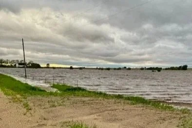
A farm field or a lake? This field in Iowa is at risk of not being able to be planted on time due to the extraordinary amount of water in the field.
Prevented planting (PP) coverage is a vital component of the federal crop insurance safety net. It provides financial stability when weather events like drought or excess rainfall make it impossible to plant crops during the spring.
However, filing a PP claim is rarely straightforward. The process is laden with documentation requirements, regulatory hurdles, and the need to prove both the condition of the field and the history of the land. For insurance agents, adjusters, and farmers alike, the process can be slow and contentious. Fortunately, Agrograph is fundamentally changing how these claims are substantiated and processed.
Proving Claim Eligibility with Satellite Data
PP coverage is generally designed to cover the costs incurred before planting a crop, including things like buying fertilizer, renting machinery, or prepping fields. To ensure the program isn't abused with claims for land that isn't typically farmed, the Risk Management Agency (RMA) has strict eligibility criteria.
One of the most notorious is the "1 in 4" Rule.
Generally, for land to be eligible for PP coverage, it must have been planted, harvested, or insured in at least one of the four previous crop years. While the specific rules of the program are constantly being refined, the core requirement remains: you must prove the land is viable cropland.
For farmers who keep meticulous records, meeting the “1 in 4” rule may not be a challenge. But what if you just acquired additional acreage, and the previous operator is unwilling to provide their records?
Once the planting window has passed, you only have 72 hours to file your notice of loss and prove your eligibility for the program. For many farmers, collecting the necessary documentation can be a major headache and can ultimately lead to a denied claim.
However, remote sensing technology is now able to provide objective, unbiased data about field history and soil conditions, which can streamline the claims processing workflow for PP insurance. Here are some of the regulatory hurdles remote sensing can help farmers overcome.
Historical Verification
If you want to file a claim for 500 acres of corn, you have to prove first that the land is viable cropland, and second, that you’ve raised 500 acres of corn in the past. The RMA accepts satellite-based data to prove that a field has been planted in the last four years. Agrograph can instantly look back five, ten, or more years across a specific land parcel to prove not only that the land was planted, but also to prove how much of the crop you have previously raised.
Assessing "Failure to Plant" Conditions
The core of a PP claim is proving that an insured cause of loss (e.g., excess rainfall) prevented planting by the deadline. If all of your neighbors were able to plant, you’ll have a harder time convincing your insurance agent that you were truly prevented from planting for an eligible reason.
Fortunately, Agrograph’s remote sensing capabilities can help with this part of a prevented planting claim as well. Agrograph utilizes radar data (which sees through clouds) and multispectral imagery to assess soil moisture saturation and precisely identify areas of standing water throughout your fields.
Defining Acreage Boundaries
Another requirement for filing a PP claim is known as the 20/20 rule. Under the 20/20 rule, a farmer can file a prevented planting claim only if at least 20 acres of the crop or 20 percent of the insured unit (whichever is smaller) could not be planted because field conditions made planting impossible.
But sometimes, only a portion of a field is prevented from planting. Accurately delineating the wettest, unplantable acres versus the acres that were eventually planted is crucial for accurate indemnity calculations.
Agrograph helps farmers demonstrate this by using time-series satellite imagery and weather data to identify which fields remained unplanted during the planting window and why.
Simplify Prevented Planting Claims with Agrograph
Integrating remote sensing into crop insurance reduces friction in the claims process for farmers, agents, and providers by providing an unbiased, data-driven baseline of field history and current conditions.
For Agents: It means faster pre-qualification of claims and less time chasing paperwork.
For AIPs (Approved Insurance Providers): It means standardized proof, reduced risk of improper payments, and a more auditable paper trail.
For Farmers: It means a faster, fairer assessment during a stressful time.
Try Agrograph to see how satellite-based field intelligence can streamline prevented planting verification and accelerate your claims workflow.