When the Planter Can’t Roll: Streamlining Prevented Planting Claims with Remote Sensing
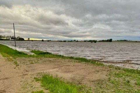
A farm field or a lake? This field in Iowa is at risk of not being able to be planted on time due to the extraordinary amount of water in the field.
How satellite data is bringing objectivity and speed to one of crop insurance’s most complex challenges—including the "1 in 4" rule.
In agriculture, the window of opportunity in the spring is tight. You have the seed, the inputs, and the equipment ready. But when the spring rains turn from a blessing into a deluge, leaving fields impassable past the final planting date, farmers are forced to make a difficult decision: file a Prevented Planting claim or not.
Prevented planting coverage is a vital component of the federal crop insurance safety net. It provides financial stability when weather events—most commonly excess moisture—make field work impossible. However, filing a PP claim is rarely straightforward. It is a process laden with documentation requirements, regulatory hurdles, and the need to prove both the condition of the field and the history of the land. For insurance agents, adjusters, and farmers alike, the process can be slow and contentious. Fortunately, Agrograph is fundamentally changing how these claims are substantiated and processed.
The Regulatory Hurdle: Proving Eligibility
A Prevented Planting claim isn’t just about the current weather; it’s also about historical land use. The Risk Management Agency (RMA) has strict eligibility criteria to ensure the program isn't abused on land that isn't typically farmed. The most notorious of these is the "1 in 4" Rule.
Generally, for land to be eligible for PP coverage, it must have been planted, harvested, or insured in at least one of the four previous crop years. While recent updates and exceptions are constantly evolving to reflect on-the-ground realities, the core requirement remains: you must prove the land is viable cropland.
In the past, proving this required digging through old records, sales receipts, or relying on anecdotal evidence. It was time-consuming and often subjective. This is where the data revolution enters the field.
At Agrograph, we leverage observations made from space to turn complex imagery into actionable insights for the insurance sector. Here is how remote sensing is streamlining the actual claims processing workflow:
Instant Historical Verification (Meeting the "1 in 4" requirement): Satellites don't have foggy memories. Agrograph can instantly look back five, ten, or more years across a specific land parcel.
Assessing "Failure to Plant" Conditions: The core of a PP claim is proving that an insured cause of loss (e.g., excess rainfall) prevented planting by the deadline. Agrograph utilizes radar data (which sees through clouds) and multispectral imagery to assess soil moisture saturation and identify areas of standing water.
Defining Acreage Boundaries: Sometimes, only a portion of a field is prevented from planting. Accurately delineating the wettest, unplantable acres versus the acres that were eventually planted is crucial for accurate indemnity calculations.
Moving from Friction to Fact
The goal of integrating remote sensing into crop insurance isn't to replace the human element of the adjuster or agent. It’s to empower them. By providing an unbiased, data-driven baseline of field history and current conditions, we reduce friction in the claims process.
For Agents: It means faster pre-qualification of claims and less time chasing paperwork.
For AIPs (Approved Insurance Providers): It means standardized proof, reduced risk of improper payments, and a more auditable paper trail.
For Farmers: It means a faster, fairer assessment during a stressful time.
The rules of crop insurance will continue to evolve, but the need for accurate, timely data remains constant. Agrograph is committed to providing the geospatial insights necessary to make the prevented planting process work better for everyone involved.